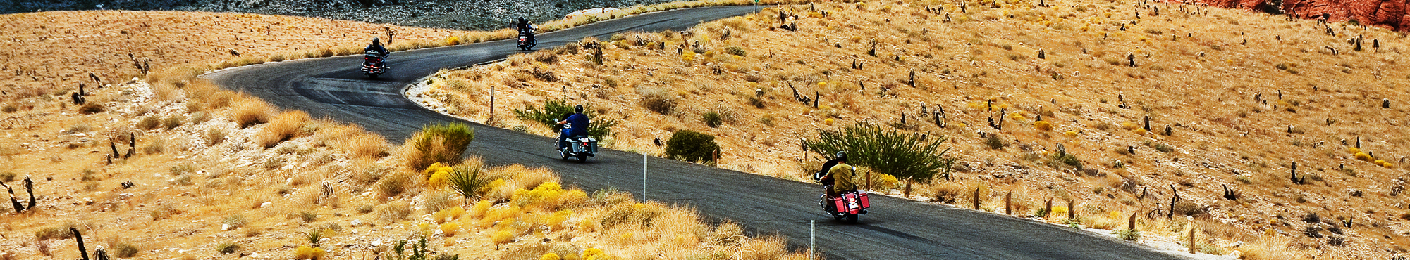
Motorcycle Roads in Colorado
For many motorcycle riders, exploring Colorado (CO) motorcycle roads is the ultimate motorcycle touring dream and perhaps the top most coveted motorcyclist destination in America. Many of America's most breathtaking stretches of the Rocky Mountains are found within this abundantly blessed state. Also, Colorado completely rolls out the red carpet for visitors and so riders will find a large array of amenities to take in when it's time to pull over and get off the bike. Some of the favorite motorcycle ride destinations are Durango, Rocky Mountain National Park, Aspen, and Silverton.
Best Rated Motorcycle Roads & Rides
Please be patient. Routes will begin to appear on map approximately 10 seconds after the map loads at a rate of one route per second.
Color Key: top-5 ranked routes in the state
#1#2#3#4#5
Routes ranked below the top-5 are drawn in gray
![San Juan Mountain Skyway | United States San Juan Mountain Skyway | United States](https://mcr-live.s3.us-west-1.amazonaws.com/route_map_original_images_drupal/map_big_image134.png)
Scenery
Ride Enjoyment
Tourism Opportunities
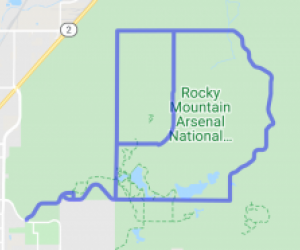
This ride will take you through arguably the most beautiful sections of the Rocky Mountains as you follow a circular path through southwestern Colorado. You will pass through historic mining towns,…
![speedo-meter](https://www.motorcycleroads.com//themes/custom/motorcycleroads/images/speedo-meter.png)
![speedo-arrow](https://www.motorcycleroads.com//themes/custom/motorcycleroads/images/speedo-arrow.png)
![speedo-meter-grey](https://www.motorcycleroads.com//themes/custom/motorcycleroads/images/rate-meter-grey.png)
![The Walden Loop (courtesy of Greeley HD&Yamaha) | United States The Walden Loop (courtesy of Greeley HD&Yamaha) | United States](https://mcr-live.s3.us-west-1.amazonaws.com/route_map_original_images_drupal/map_big_image135.png)
Scenery
Ride Enjoyment
Tourism Opportunities
Absolutely breathtaking is the only way to describe this trip. This route will take you across the Continental Divide twice at two different locations, past mountain lakes and through Poudre Canyon…
![speedo-meter](https://www.motorcycleroads.com//themes/custom/motorcycleroads/images/speedo-meter.png)
![speedo-arrow](https://www.motorcycleroads.com//themes/custom/motorcycleroads/images/speedo-arrow.png)
![speedo-meter-grey](https://www.motorcycleroads.com//themes/custom/motorcycleroads/images/rate-meter-grey.png)
![Peak to Peak Highway | United States Peak to Peak Highway | United States](https://mcr-live.s3.us-west-1.amazonaws.com/route_map_original_images_drupal/map_big_image141.png)
Scenery
Ride Enjoyment
Tourism Opportunities
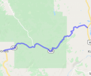
Depending on which canyon you start with you will go through some of the most spectacular mountain scenery close to the Denver-Metro area. The National Scenic Byway Program describes the Peak to Peak…
![speedo-meter](https://www.motorcycleroads.com//themes/custom/motorcycleroads/images/speedo-meter.png)
![speedo-arrow](https://www.motorcycleroads.com//themes/custom/motorcycleroads/images/speedo-arrow.png)
![speedo-meter-grey](https://www.motorcycleroads.com//themes/custom/motorcycleroads/images/rate-meter-grey.png)
![Unaweep Tabeguache Scenic Road - CO 141 | United States Unaweep Tabeguache Scenic Road - CO 141 | United States](https://mcr-live.s3.us-west-1.amazonaws.com/route_map_original_images_drupal/map_big_image718.png)
Scenery
Ride Enjoyment
Tourism Opportunities
Breathtaking vistas and a sky so blue that looks surreal in contrast with the red rocks. The traffic seems to be very light. Make you feel you are riding inside a miniature Grand Canyon. There's a…
![speedo-meter](https://www.motorcycleroads.com//themes/custom/motorcycleroads/images/speedo-meter.png)
![speedo-arrow](https://www.motorcycleroads.com//themes/custom/motorcycleroads/images/speedo-arrow.png)
![speedo-meter-grey](https://www.motorcycleroads.com//themes/custom/motorcycleroads/images/rate-meter-grey.png)
![The Black Canyon Run | United States The Black Canyon Run | United States](https://mcr-live.s3.us-west-1.amazonaws.com/route_map_original_images_drupal/map_big_image144.png)
Scenery
Ride Enjoyment
Tourism Opportunities
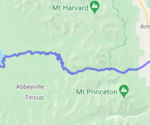
The scenery ranges from scrub desert to alpine aspen groves, with spectacular views of the incredible Black Canyon down below. It begins at the Blue Mesa Reservoir and rides along a shelf of mesas…
![speedo-meter](https://www.motorcycleroads.com//themes/custom/motorcycleroads/images/speedo-meter.png)
![speedo-arrow](https://www.motorcycleroads.com//themes/custom/motorcycleroads/images/speedo-arrow.png)
![speedo-meter-grey](https://www.motorcycleroads.com//themes/custom/motorcycleroads/images/rate-meter-grey.png)
![The "High 5" to Mt. Evans | United States The "High 5" to Mt. Evans | United States](https://mcr-live.s3.us-west-1.amazonaws.com/route_map_original_images_drupal/map_big_image145.png)
Scenery
Ride Enjoyment
Tourism Opportunities
Mountain tops! You are looking down at most of Colorado's mountain peaks! This is the highest paved road in the US! Goes over 14,264 feet. Get near the edge and she's quite a thrill! Not for the…
![speedo-meter](https://www.motorcycleroads.com//themes/custom/motorcycleroads/images/speedo-meter.png)
![speedo-arrow](https://www.motorcycleroads.com//themes/custom/motorcycleroads/images/speedo-arrow.png)
![speedo-meter-grey](https://www.motorcycleroads.com//themes/custom/motorcycleroads/images/rate-meter-grey.png)
![Independence Pass (State Route 82) | United States Independence Pass (State Route 82) | United States](https://mcr-live.s3.us-west-1.amazonaws.com/route_map_original_images_drupal/map_big_image143.png)
Scenery
Ride Enjoyment
Tourism Opportunities
Typical dense forest at the lower elevations with endless switchbacks. Ghost town of Independence near the top of the pass. Breath taking views of the famous Maroon Bells area of the Colorado Rocky…
![speedo-meter](https://www.motorcycleroads.com//themes/custom/motorcycleroads/images/speedo-meter.png)
![speedo-arrow](https://www.motorcycleroads.com//themes/custom/motorcycleroads/images/speedo-arrow.png)
![speedo-meter-grey](https://www.motorcycleroads.com//themes/custom/motorcycleroads/images/rate-meter-grey.png)
![Pikes Peak Run | United States Pikes Peak Run | United States](https://mcr-live.s3.us-west-1.amazonaws.com/route_map_original_images_drupal/map_big_image1345.png)
Scenery
Ride Enjoyment
Tourism Opportunities
You will first start off with lots of heavy trees and will even see cross over Crystal Creek Reservoir, and then gradually you will start to see some thinning of trees as you get higher in elevation…
![speedo-meter](https://www.motorcycleroads.com//themes/custom/motorcycleroads/images/speedo-meter.png)
![speedo-arrow](https://www.motorcycleroads.com//themes/custom/motorcycleroads/images/speedo-arrow.png)
![speedo-meter-grey](https://www.motorcycleroads.com//themes/custom/motorcycleroads/images/rate-meter-grey.png)
![Colorado Route 149 - South Fork to Gunnison | United States Colorado Route 149 - South Fork to Gunnison | United States](https://mcr-live.s3.us-west-1.amazonaws.com/route_map_original_images_drupal/map_big_image840.png)
Scenery
Ride Enjoyment
Tourism Opportunities
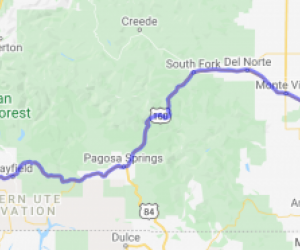
Route 149 is one the most scenic roads I have ever been on. Scenery wise you have it all - stunning views of the mountains , a ride a long the banks of a river, and sections that ride next to…
![speedo-meter](https://www.motorcycleroads.com//themes/custom/motorcycleroads/images/speedo-meter.png)
![speedo-arrow](https://www.motorcycleroads.com//themes/custom/motorcycleroads/images/speedo-arrow.png)
![speedo-meter-grey](https://www.motorcycleroads.com//themes/custom/motorcycleroads/images/rate-meter-grey.png)
![Grand Mesa - Colorado State Route 65 | United States Grand Mesa - Colorado State Route 65 | United States](https://mcr-live.s3.us-west-1.amazonaws.com/route_map_original_images_drupal/map_big_image140.png)
Scenery
Ride Enjoyment
Tourism Opportunities
Western Colorado desert canyons to high mountain forests, 50 mile vista's, wildlife. Breath taking is the word. Hard to keep your eyes on the road. Bring a camera. About 1/2 through National Forest…
![speedo-meter](https://www.motorcycleroads.com//themes/custom/motorcycleroads/images/speedo-meter.png)
![speedo-arrow](https://www.motorcycleroads.com//themes/custom/motorcycleroads/images/speedo-arrow.png)
![speedo-meter-grey](https://www.motorcycleroads.com//themes/custom/motorcycleroads/images/rate-meter-grey.png)
![Highway 77 to Colorado's Mini Devil's Tower | United States Highway 77 to Colorado's Mini Devil's Tower | United States](https://mcr-live.s3.us-west-1.amazonaws.com/route_map_original_images_drupal/map_big_image139.png)
Scenery
Ride Enjoyment
Tourism Opportunities
The scenery is wonderful. All kinds of wildlife were roaming the day we rode. This is particular stretch of Colorado mountain road covers some flat terrain but has multiple rock formations along the…
![speedo-meter](https://www.motorcycleroads.com//themes/custom/motorcycleroads/images/speedo-meter.png)
![speedo-arrow](https://www.motorcycleroads.com//themes/custom/motorcycleroads/images/speedo-arrow.png)
![speedo-meter-grey](https://www.motorcycleroads.com//themes/custom/motorcycleroads/images/rate-meter-grey.png)
![Cortez to Mesa Verde National Park | United States Cortez to Mesa Verde National Park | United States](https://mcr-live.s3.us-west-1.amazonaws.com/route_map_original_images_drupal/map_big_image132.png)
Scenery
Ride Enjoyment
Tourism Opportunities
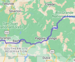
Highway 160 from Cortez to the park entrance is good scenery. Upon entering the park the scenery greatly improves. With several great vistas down into the valley and towards the Colorado Rockies.…
![speedo-meter](https://www.motorcycleroads.com//themes/custom/motorcycleroads/images/speedo-meter.png)
![speedo-arrow](https://www.motorcycleroads.com//themes/custom/motorcycleroads/images/speedo-arrow.png)
![speedo-meter-grey](https://www.motorcycleroads.com//themes/custom/motorcycleroads/images/rate-meter-grey.png)
![Poncha Springs Loop | United States Poncha Springs Loop | United States](https://mcr-live.s3.us-west-1.amazonaws.com/route_map_original_images_drupal/map_big_image142.png)
Scenery
Ride Enjoyment
Tourism Opportunities
October colors are great and the varies from hills and plains to rocky and steep mountainsides. You'll be riding through Rocky Mountain high country in south central Colorado and travel through…
![speedo-meter](https://www.motorcycleroads.com//themes/custom/motorcycleroads/images/speedo-meter.png)
![speedo-arrow](https://www.motorcycleroads.com//themes/custom/motorcycleroads/images/speedo-arrow.png)
![speedo-meter-grey](https://www.motorcycleroads.com//themes/custom/motorcycleroads/images/rate-meter-grey.png)
![Snowy Range & Woods Landing Loop | Colorado Snowy Range & Woods Landing Loop | Colorado](https://mcr-live.s3.us-west-1.amazonaws.com/route_map_original_images_drupal/map_big_image1358.png)
Scenery
Ride Enjoyment
Tourism Opportunities
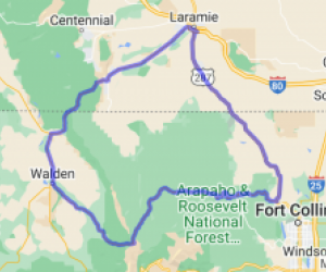
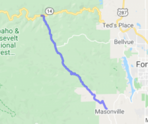
This loop ride travels first through the North Platte River valley before heading east toward Laramie. In this section of highway, you will increase in elevation, topping out at Libby Flats at 10,…
![speedo-meter](https://www.motorcycleroads.com//themes/custom/motorcycleroads/images/speedo-meter.png)
![speedo-arrow](https://www.motorcycleroads.com//themes/custom/motorcycleroads/images/speedo-arrow.png)
![speedo-meter-grey](https://www.motorcycleroads.com//themes/custom/motorcycleroads/images/rate-meter-grey.png)
![Loma to Rangely on Rt 139 | United States Loma to Rangely on Rt 139 | United States](https://mcr-live.s3.us-west-1.amazonaws.com/route_map_original_images_drupal/map_big_image1485.png)
Scenery
Ride Enjoyment
Tourism Opportunities
Loma has only a convenience store for gas and snacks, but they welcome bikers. Generally, Loma is a small farming/ranching town.
This trip has three main attractions, however, the beginning isn't…
![speedo-meter](https://www.motorcycleroads.com//themes/custom/motorcycleroads/images/speedo-meter.png)
![speedo-arrow](https://www.motorcycleroads.com//themes/custom/motorcycleroads/images/speedo-arrow.png)
![speedo-meter-grey](https://www.motorcycleroads.com//themes/custom/motorcycleroads/images/rate-meter-grey.png)
![Moab, UT to Nucla, CO | Utah Moab, UT to Nucla, CO | Utah](https://mcr-live.s3.us-west-1.amazonaws.com/route_map_original_images_drupal/map_big_image582.png)
Scenery
Ride Enjoyment
Tourism Opportunities
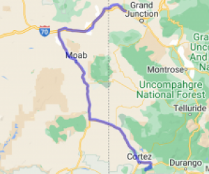
Great views of the La Sals, big valleys, farm country, and desert - all on one road. The road follows a stream along the edge of Mt. Peale - elevation 12,721.
![speedo-meter](https://www.motorcycleroads.com//themes/custom/motorcycleroads/images/speedo-meter.png)
![speedo-arrow](https://www.motorcycleroads.com//themes/custom/motorcycleroads/images/speedo-arrow.png)
![speedo-meter-grey](https://www.motorcycleroads.com//themes/custom/motorcycleroads/images/rate-meter-grey.png)
![Cottonwood Pass - Taylor Park to Buena Vista | United States Cottonwood Pass - Taylor Park to Buena Vista | United States](https://mcr-live.s3.us-west-1.amazonaws.com/route_map_original_images_drupal/map_image62736.png)
Scenery
Ride Enjoyment
Tourism Opportunities
This is pretty much a regular old Colorado mountain road with a lake in a park (a large low area in the mountains) surrounded by 12,000’ peaks all around in the distance, frequently with snowcapped…
![speedo-meter](https://www.motorcycleroads.com//themes/custom/motorcycleroads/images/speedo-meter.png)
![speedo-arrow](https://www.motorcycleroads.com//themes/custom/motorcycleroads/images/speedo-arrow.png)
![speedo-meter-grey](https://www.motorcycleroads.com//themes/custom/motorcycleroads/images/rate-meter-grey.png)
![The Steamboat Scream | United States The Steamboat Scream | United States](https://mcr-live.s3.us-west-1.amazonaws.com/route_map_original_images_drupal/map_big_image136.png)
Scenery
Ride Enjoyment
Tourism Opportunities
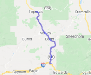
This route takes you from one of Colorado's largest and most beautiful mountain lakes to town of Steamboat Springs Colorado. You will start out at the South end of Lake Granby. From there you can see…
![speedo-meter](https://www.motorcycleroads.com//themes/custom/motorcycleroads/images/speedo-meter.png)
![speedo-arrow](https://www.motorcycleroads.com//themes/custom/motorcycleroads/images/speedo-arrow.png)
![speedo-meter-grey](https://www.motorcycleroads.com//themes/custom/motorcycleroads/images/rate-meter-grey.png)
![Two Canyons - West of Denver | United States Two Canyons - West of Denver | United States](https://mcr-live.s3.us-west-1.amazonaws.com/route_map_original_images_drupal/map_big_image2644.png)
Scenery
Ride Enjoyment
Tourism Opportunities
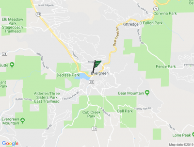
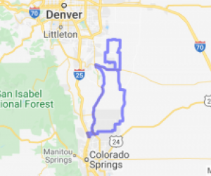
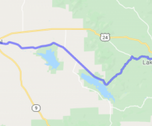
This route covers two of the most gorgeous canyons in Colorado - Clear Creek Canyon going up and Bear Creek Canyon coming back down - as you ascend from Golden, pass through Evergreen, and end up…
![speedo-meter](https://www.motorcycleroads.com//themes/custom/motorcycleroads/images/speedo-meter.png)
![speedo-arrow](https://www.motorcycleroads.com//themes/custom/motorcycleroads/images/speedo-arrow.png)
![speedo-meter-grey](https://www.motorcycleroads.com//themes/custom/motorcycleroads/images/rate-meter-grey.png)
![Lookout Mountain Road | United States Lookout Mountain Road | United States](https://mcr-live.s3.us-west-1.amazonaws.com/route_map_original_images_drupal/map_big_image1976.png)
Scenery
Ride Enjoyment
Tourism Opportunities
Wonderful view of the Golden & the Denver Metro area when you reach the summit.
![speedo-meter](https://www.motorcycleroads.com//themes/custom/motorcycleroads/images/speedo-meter.png)
![speedo-arrow](https://www.motorcycleroads.com//themes/custom/motorcycleroads/images/speedo-arrow.png)
![speedo-meter-grey](https://www.motorcycleroads.com//themes/custom/motorcycleroads/images/rate-meter-grey.png)