Motorcycle Route Author

By Guest (0 McR Points)
on Jul 01, 2005
Rider Reviews
Written Directions
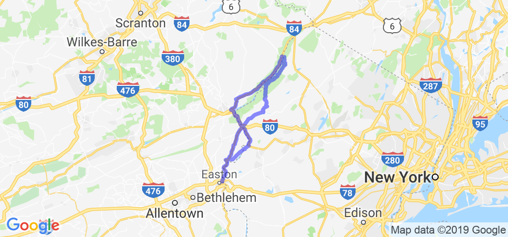
Start your route in Easton, PA. From US 22 at the NJ border take state route 611 north along the Delaware River. About 7 miles up the road, look for Martins Creek Belvidere Highway and turn right (east). Take Martins Creek Belvidere Highway and take the iron bridge and over the Delaware River into Belvidere, NJ. Make a left on Market (1st Light) and make a right on Manunkachunk Rd, then make a left on state route 46. Take this to I-80, get on I-80 west toward Delaware Water Gap. Take exit 1, and make a right on Old Mine Rd. (Note: Several routes go through De Water Gap Recreational area, some parts of Old Mine Rd can be in poor shape. I saw very few bad spots, but use 640 (Wallpack Flatbrookville Rd) as an alternate if you're concerned.) Stay on Old Mine Rd for about 27 miles and you'll intersect state route 560 where you make a left and head west on 560 and cross Dingman's Ferry Bridge ($.75 toll I think). After that get on 209S (south) and take it all the way down to Stroudsburg (about 24 miles). From Stroudsburg getting back to Easton is easy as all you have to do is follow the pretty route 611S all the way back to Easton PA ... doing this will complete the loop (total about 150 miles).Scenery
Follows the Delaware River from Easton, PA to Dingman's Ferry. River scenery, rolling hills, mountains, forest. It has it all!Note: The abandoned town of Wallpack Center has an interesting story behind it, park at the Post Office and check out the Historical Society next door if you'd like to hear it.
Drive Enjoyment
It's a fairly slow scenic route with lots of twists. Roads vary from excellent to fair depending on route and recent weather. Watch for gravel if it's rained recently.Tourism Opportunities
Many scenic stops, parks, campgrounds, river access points, and museums on the route, a few interesting restaurants as well. You'll pass by/through the Worthington State Forest and the Delware Water Gap National Recreation Area.Motorcycle Road Additional info
- View the weather forecast for this area from Yahoo weather.Top Images

Gyro-HD
October 19, 2014
14 McR Points
Motorcycle Type : Touring
I have ridden this road many times and it is a very nice route. However, the traffic on 209 from Stroudsburg to Bushkill is a nightmare during the summer; many stops and generally heavy traffic.
Also be aware that the federal lands along the river are heavily patrolled by National Park Service rangers. They practice giving out tickets on a grand scale. I was pinched for not slowing down through a construction zone on labor day weekend. No construction vehicles in sight but they had three cars writing tickets non-stop.
The NJ side of the river doesn't have as much a view of the river as the PA side, but it's a very nice ride through rural NJ with very little traffic. I thought the road surface was a little better on the NJ side.
Was this road review helpful?
Thumbsup
2 riders found this road review useful

Guest
September 1, 2010
0 McR Points
Motorcycle Type : Cruiser
I am thinking of doing this over the Labor Day weekend. John or Mike, would the return trip back down the other side be better on River Road?
Was this road review helpful?
Thumbsup
1 riders found this road review useful

Guest
October 26, 2012
0 McR Points
Motorcycle Type : Cruiser
I live a few miles from this route and ride it quite often. I would suggest staying on 611 North in PA instead of crossing into NJ and taking the interstate. If you do, it takes you north along the river and through some nice, easy twisties...nothing crazy...and has some nice scenic pull-offs that overlook the river as strategic viewing points. I also use this route to take my little Ninja 500 for vigorous workouts.
Was this road review helpful?
Thumbsup
0 riders found this road review useful
Photo Gallery of Delaware Water Gap Loop (1 Photos)

Video
RT 6 PA. Delaware Water Gap Harley Ride
0
Thumbsup

Video
0
Interactive Views Along This Route
Start point
Latitude 40.69135
Longitude -75.20659
Way point 1
Latitude 40.844074
Longitude -75.057049
Way point 2
Latitude 41.101151
Longitude -74.962378
Way point 3
Latitude 41.194738
Longitude -74.864531
Way point 4
Latitude 41.22096
Longitude -74.85596
Way point 5
Latitude 41.222891
Longitude -74.870882
End point
Latitude 40.696778
Longitude -75.203819