Written Directions
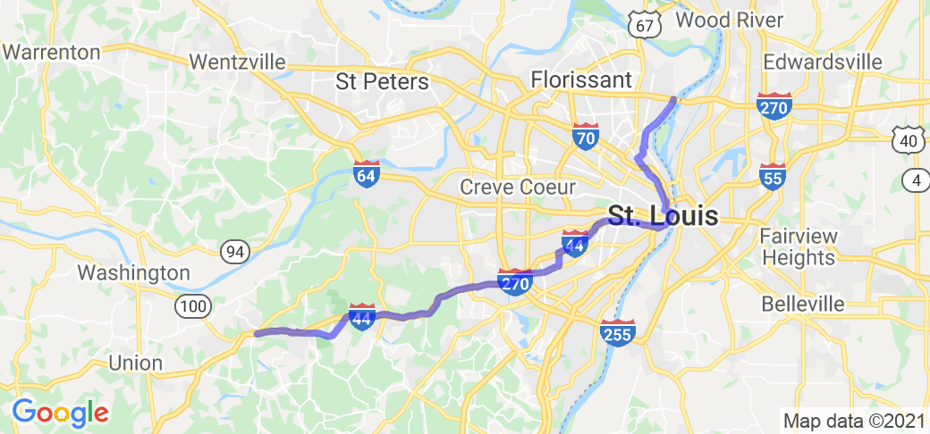
The Starting point is at the entrance to the Chain of Rocks Bridge, 0.2 miles south of the intersection of I-270 and Riverview Dr. (exit 34). Proceed south on Riverview Dr. for 3.7 miles, then turn left on N. Broadway. Go 1.7 miles, then turn right onto N. Calvary Ave., continuing on to Calvary Ave. Go 0,6 miles, then turn left onto W. Florissant Ave. In 2,3 miles, continue across Grand Blvd onto N. Florissant Ave., then continue for 2.1 miles. Follow the road onto N. 13th Street, then onto N. Tucker Blvd. Continue for 2.1 miles, then continue onto Gravois Ave. Continue for 3 miles, then turn right onto Chippewa St. (MO-366). Continue for 9.5 miles (Chippewa St. will become Watson Rd going from St. Louis City to St. Louis County). Take the on ramp to I-44, and continue for 15.3 miles. Take exit 261 (Six Flags Rd). Turn left onto Six Flags Rd, proceed under the highway, then turn right onto I-44 Business Loop/Historic Route 66. Continue for 8.8 miles to the intersection of Historic Route 66 and MO-100.
Scenery
The route starts at the historic Chain of Rocks Bridge and follows the Mississippi River riverfront before turning onto Broadway. A brief passage through the historic Bellefontaine and Calvary Cemeteries, then through some north St. Louis City neighborhoods, downtown St. Louis (going past City Hall) and then into South St. Louis, before crossing into St. Louis County and suburban neighborhoods. The I-44 section is typical interstate, although the stretch over Antire Ridge is notable. Once back on the 1936 route just past the Six Flags amusement park, the road goes past bluffs that were used for mining silica in the 19th and early 20th century, and is more typical of the historic Route 66 roads.
Drive Enjoyment
The route is a mix of both well maintained and in need of maintenance city streets until you reach Chippewa Street. At this point, the route is maintained by the Missouri Department of Transportation, as is I-44, which is generally well maintained, although there may be some areas in need of work.
Tourism Opportunities
The route has many opportunities, starting with the Chain of Rocks Bridge. The route goes through downtown St. Louis, within sight of the Gateway Arch, and there are numerous attractions and restaurants. Once into St. Louis County, you'll notice several classic Route 66 motels (sadly, the famed Coral Court Motel was demolished in 1995) along the route. Stopping at the visitors center at the Route 66 State Park (which is on the east side of the Meramec River, while the rest of the park, the former village of Times Beach, is on the west side) is a must - take exit 266 on I-44. Consult with a St. Louis area or Route 66 tourist guide for all of the attractions.
Motorcycle Road Additional info
NOTE: The Google Maps route does not follow the directions, due to the limitation on waypoints. Either use the written directions, or this route in the Harley-Davidson Ride Planner: https://maps.harley-davidson.com/share/rides/lYKssS9gL
The route follows the 1936 "City" alignment from the Chain of Rocks Bridge through St. Louis as closely as is possible. There were also "official" crossings of the Mississippi River on the McKinley Bridge, the Veterans (now Martin Luther King, Jr.) Bridge and the Municipal (now MacArthur) Bridge (now closed), which connected to the route, as well. The "official" route through St. Louis City changed on an almost yearly basis, so there are many ways to get to Chippewa St./Watson Road, which became the official route in 1934 (shifting from Manchester Road further to the north). I-44 from the end of Watson Rd to Six Flags is on the actual 1936 alignment.


 Write a review


