Written Directions
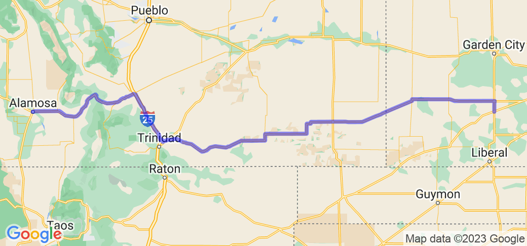
335 mi. About 5 hours 31 mins
1. Head north on S Inman St toward Becknell Ave 0.1 mi
2. Turn right at the 2nd cross street onto US-56 E / E la Lande Ave 0.5 mi
3. Turn left onto Co Rd OO 5.3 mi
4. Turn left onto KS-144 W 1.8 mi
5. Continue onto US-160 W 49.1 mi
6. Turn right onto KS-27 N 27.9 mi
7. Turn left onto US-50 W /Ave A Continue to follow US-50 W Entering Colorado 43.2 mi
8. Turn right onto Co Rd 13 1.5 mi
9. Turn left onto CO-196 5.3 mi
10. Continue straight onto State Hwy 287 0.1 mi
11. Turn right onto US-287 N / US-50 W Continue to follow US-50 W 33.1 mi
12. Keep left to stay on US-50 W Pass by Pizza Hut (on the left in 20.3 mi)
21.9 mi
13. Turn left onto CO-10 W/Dalton Ave 0.3 mi
14. Turn right onto CO-10 W/W 4th St Continue to follow CO-10 W 71.3 mi
15. Continue onto US-160 W 1.0 mi
16. Turn left onto US-160 W/Main St 0.1 mi
17. Turn right at the 2nd cross street onto US-160 W/W 7th St. Continue to follow US-160 W 71.7 mi
18. Turn right onto Fourth St
Scenery
This segment transitions from straight and flat, to brush and gullys with some rolling hills and long sweeps. Once you get to Walsenburg, you hit the first mountain pass. Rising terrrain and good leaning curves are from here to the Great Dunes National Park. Be careful from Fort Garland to Alamosa: very open windy sections can be expected with sand in the air.
Drive Enjoyment
This is the least technical mountain pass on the whole trip. Road has sections with a passing lane and can be taken at highway speeds.
Tourism Opportunities
This segment passes through some national forests land so the scenery gets more interesting with pine trees and some wildlife. Coming out of the pass, you are getting close to the Great Dunes Natioal Park and it is worth the short side trip.
Motorcycle Road Additional info
Thia is Day 2 or the Edge of Colorado Route.























































 Write a review
