Written Directions
This ride features rolling hills, farm land, and wooded areas with elevation changes indicative of the Susquehanna River Valley. The roads are in good repair and are well marked for this part of York and Lancaster County.
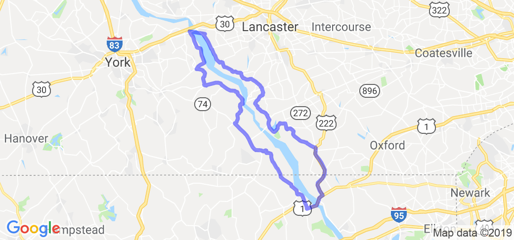
The ride starts off in the little borough of Wrightsville, Pennsylvania at the John Wright Restaurant and ends across the river in Columbia at the Turkey Hill Experience.
Starting from the John Wright Restaurant, head south on North Front Street, (Rt. 624). Once you cross under the Wrights Ferry Bridge, Lincoln Highway (Rt. 462), the road turns into South Front Street. The Susquehanna River will be on your left. Once you leave Wrightsville the road becomes Long Level Road. There is one descent elevation change with cool damp air as you leave town (you'll know it when you ride through it). Along this road you'll pass through the beautiful Lauxmont Farm on the way to Long Level. Located in the Long Level area is the Long Level Marina and the Lake Clark Rescue. Watch for the first "Y" in the road. You'll want to stay left and stay on Long Level Road. Continue for about 1/2 mile until you reach another Y" in the road. This is Bull Run Road, turn right. After traveling approximately one mile up hill, turn left onto Pleasant Hill Road. Continue until you reach PA-425 S/Craley Road/New Bridgeville Road.
Now for my favorite part of this run. There are nice curves and elevation changes. The road is flanked on both sides with dense woods, brush and lots of shade. Continue to follow PA-425 S/Craley Road for about 2.5 miles and turn left onto PA-425 S/Burkholder Road. Continue to follow PA-425 S for 7.5 miles. At this point you can turn left onto Indian Steps Road and visit the Indian Steps Museum or make the sharp right hander and continue on PA-425 S/Furnace Road. At the intersection turn left onto Rt. 74 Delta Road.
Once you turn onto Delta Road, the Airville Fire Department will be on your right. At this point of Rt. 74, the road is a pretty uneventful road, although, nice scenery with one left hand sweeping curve. (NOTE: If you would like to cut this ride in half, turn left onto Holtwood road and proceed across the Norman Wood Bridge then left onto Old Pinnacle Road. Continue with directions below). Just after the left hand sweeper, Rt. 74 turns sharp right. At the sharp right, continue straight onto Paper Mill Road/State Route 2024 for 2 miles. Turn right onto Flintville Road/State Route 2043. Flintville Road can be pretty rough so go slow and easy. Continue to follow Flintville Road and cross over into Maryland.
After about 8 miles turn left onto MD-623/Castleton Road. Follow Castleton Road for 3 miles. Turn left onto U.S. 1 N/Conowingo Road. You will cross over the Susquehanna River via the Conowingo Hydroelectric Dam.
Once over the dam you can turn right onto US-222 South and head to the Union Hotel Restaurant for a little refreshment. It is about a mile or so down on the left.
Back to U.S. 1 North /Conowingo Road. This part of the ride has the same type of elevation changes and road conditions as York County. At the first intersection, (there is a Royal Farm Store) turn left onto US-222 N/Rock Springs Road, Continue for 8.1 miles crossing into Pennsylvania. Turn left onto Furniss Road and travel about 6.5 miles and turn left back onto River Road. Continue on for 4 miles. You'll cross over Muddy Run Recreation Reservoir. At the intersection, turn right onto Rt. 372 Holtwood Road and turn left onto River Road.
(NOTE: If proceeding from Holtwood Road continue here)
Turning left onto River Road/State Route 3017. River Hill Road and turn left onto River Road. Follow River Road until making a left onto Herr Stre Follow River Road for 17.5 miles. After which turns into Herr Street for 350 feet. Herr Street turns right and becomes Water Street follow for about 2.5 miles, which turns into South Front Street. Once in Columbia, turn right onto Locust Street. Take the 2nd left onto N 3rd Street. Follow for about a 1/2 mile and turn right onto Linden Street. The Turkey Hill Experience will be on your left.
Scenery
Scenery along this route is typical Susquehanna Valley, rolling hills, farm land, with some small town charm. There are numerous areas to pull over and enjoy a scenic overlook of the Susquehanna River. This is Pennsylvania Amish Country so keep an eye out for horse and buggies. During the fall months the fall foliage is magnificent throughout the route.The views from the Norman Wood Bridge and the Conowingo Dam are outstanding any time of the year.
Drive Enjoyment
The route has a good mixture of curves and elevation changes and wide open straights. Some areas are bright and sunny while others are shaded. Be aware of these areas after rain as they might not be totally dry when compared to the rest of the road surface. Speaking of the road surface, most of the roadway is smooth asphalt with areas of tar and chip pavement. Traffic along this route is usually light. Although some heavier traffic can be found along Route 74 (Delta Road), Route 372 (Holtwood Road), and Conowingo Road (U.S.1), so be aware of passing tractor trailers and heavy equipment. Due to severe weather the roads close to the river in the south west section of Lancaster are not suitable for motorcycle travel.
Tourism Opportunities
This ride has relatively few amenities, but with its short duration this really shouldn't be a problem. Wrightsville has the typical fuel /convenience stores and small town restaurants. Chesapeake H-D is at the corner of Castleton Road and Conowingo Road, just west of the Conowingo Dam. On the western bank of the Susquehanna River prior to crossing the Conowingo Dam is the Conowingo Visitors Center and Recreation Office. There is a pool and a small Recreation office. The above mentioned Union Hotel Restaurant and Royal Farm Store are just east of the Conowingo Dam. Located off Susquehannock Road is Susquehannock State park. The park can be accessed from State Park Road off of Susquehannock Road. This is a nice place for a picnic. The park has 5 miles of trails and scenic over looks of the river. Camping is by reservation only. In Columbia, again there are fuel /convenience stores and restaurants.
Motorcycle Road Additional info
Getting off the route indicated is of no big consequence, as all surrounding roads are similar and lead to the same places, generally. Don't be too concerned if you get lost. One look at the map and it is easy to find your way back to the route or find a route heading for home. On the York County side you will run into Route 74 which runs north and south. On the Lancaster side you will run into Route 272 or Route 222, both running north and south. In Maryland U.S. 1 runs east and west. So you will eventually find one of these roads should you become lost.


 Write a review