Overall Route Rating
speedo-meter speedo-arrow
speedo-meter-grey
3.4 out of 5 Rider Rating 3.4
5 Reviews

Motorcycle Route Author

profile Image
By Guest (0 McR Points) on Jun 30, 2005

Rider Reviews

Gyro-HD
14 McR Points
October 18, 2014
I have ridden this road many times and it is a…
Thumbsup
No Image Found
Guest
August 31, 2010
I am thinking of doing this over the Labor Day…
Thumbsup

Written Directions

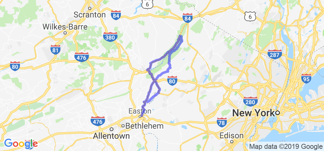
Start your route in Easton, PA. From US 22 at the NJ border take state route 611 north along the Delaware River. About 7 miles up the road, look for Martins Creek Belvidere Highway and turn right (east). Take Martins Creek Belvidere Highway and take the iron bridge and over the Delaware River into Belvidere, NJ. Make a left on Market (1st Light) and make a right on Manunkachunk Rd, then make a left on state route 46. Take this to I-80, get on I-80 west toward Delaware Water Gap. Take exit 1, and make a right on Old Mine Rd. (Note: Several routes go through De Water Gap Recreational area, some parts of Old Mine Rd can be in poor shape. I saw very few bad spots, but use 640 (Wallpack Flatbrookville Rd) as an alternate if you're concerned.) Stay on Old Mine Rd for about 27 miles and you'll intersect state route 560 where you make a left and head west on 560 and cross Dingman's Ferry Bridge ($.75 toll I think). After that get on 209S (south) and take it all the way down to Stroudsburg (about 24 miles). From Stroudsburg getting back to Easton is easy as all you have to do is follow the pretty route 611S all the way back to Easton PA ... doing this will complete the loop (total about 150 miles).

Scenery

Follows the Delaware River from Easton, PA to Dingman's Ferry. River scenery, rolling hills, mountains, forest. It has it all!

Note: The abandoned town of Wallpack Center has an interesting story behind it, park at the Post Office and check out the Historical Society next door if you'd like to hear it.

Drive Enjoyment

It's a fairly slow scenic route with lots of twists. Roads vary from excellent to fair depending on route and recent weather. Watch for gravel if it's rained recently.

Tourism Opportunities

Many scenic stops, parks, campgrounds, river access points, and museums on the route, a few interesting restaurants as well. You'll pass by/through the Worthington State Forest and the Delware Water Gap National Recreation Area.

Motorcycle Road Additional info

- View the weather forecast for this area from Yahoo weather.
 

Top Images

Share Your Comments ( 5 )
  Earn McR Points
No Image Found
Guest
September 5, 2010
0 McR Points
Motorcycle Type : Cruiser
Just completed the loop. It was a lot of fun. The only reason I gave it a 7 instead of higher, was that all of the forests block your view of the water. There are several scenic stops though. It would probably be better in the fall. Here is a custom map from Turkey Hill in Easton, PA. https://goo.gl/maps/dVC2. It does have a twist though... I did something different Southbound. I stayed on River Road instead of taking 209 through Bushkill. There was a growing traffic jam through Bushkill on 209. I was eating lunch just past Community Rd. which is the turn off that you want off of 209 to get to River Rd. CAUTION: If you eat lunch in Bushkill, then head back North to get onto community Road, it is a hairpin turn. My big cruiser and I lost our footing trying to walk the bike around the hairpin (gravel and dust). Thanks to all of the fine gentlemen that helped me lift 750 pounds. Barely a scratch. My floorboards saved everything. Who says you need engine guards? Do not let that discourage you. The roads are awesome and if you do not go into Bushkill, and turn onto Community Road while going Southbound on 209, you'll be fine.
Was this road review helpful?
Thumbsup
0 riders found this road review useful
No Image Found
Guest
July 24, 2009
0 McR Points
Motorcycle Type : Touring
very nice route. roads can be tricky . many other routes in same areaif you want to stay in pa
Was this road review helpful?
Thumbsup
0 riders found this road review useful